This site will look much better in a browser that supports web standards, but it is accessible to any browser or Internet device.


blog0news


  • O BRASIL EH O QUE ME ENVENENA MAS EH O QUE ME CURA (LUIZ ANTONIO SIMAS)

  • Vislumbres

    Powered by Blogger

    Fragmentos de textos e imagens catadas nesta tela, capturadas desta web, varridas de jornais, revistas, livros, sons, filtradas pelos olhos e ouvidos e escorrendo pelos dedos para serem derramadas sobre as teclas... e viverem eterna e instanta neamente num logradouro digital. Desagua douro de pensa mentos.


    terça-feira, junho 11, 2019

    The Roads of Ancient Rome Visualized in the Style of Modern Subway Maps | Open Culture


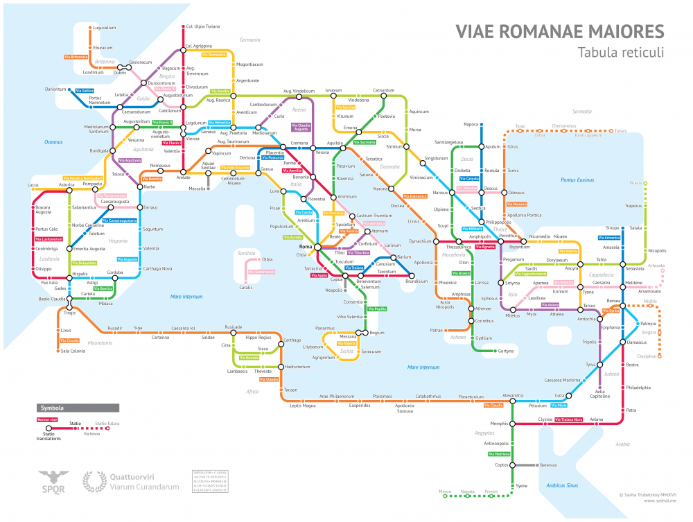
    "Sasha Trubetskoy, an undergrad at U. Chicago, has created a "subway-style diagram of the major Roman roads, based on the Empire of ca. 125 AD." Drawing on Stanford’s ORBIS modelThe Pelagios Project, and the Antonine Itinerary, Trubetskoy's map combines well-known historic roads, like the Via Appia, with lesser-known ones (in somes cases given imagined names). If you want to get a sense of scale, it would take, Trubetskoy tells us, "two months to walk on foot from Rome to Byzantium. If you had a horse, it would only take you a month."

    The Roads of Ancient Rome Visualized in the Style of Modern Subway Maps | Open Culture

    0 Comentários:

    Postar um comentário

    Assinar Postar comentários [Atom]

    << Home


    e o blog0news continua…
    visite a lista de arquivos na coluna da esquerda
    para passear pelos posts passados


    Mas uso mesmo é o

    ESTATÍSTICAS SITEMETER